You imagine a wide road (latitudinal 10 and more meters), layered with thick, heavy marble slabs, bordered by marble curbs and colonnades, and on this road move chariots and pedestrians and animals and soldiers and emperors and…
And on a street corner – of the not so crowded despite the "maximus" of his character – to be engraved, almost artificial, a huge frenzy; Yes, the famous game that is still played today. And... I was thrilled to see Roman soldiers and centurions playing in the middle of the street;
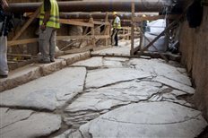
The oversized trill of decumanus maximus (ancestor of today's Egnatia street) was located at the height of today's Agia Sophia street, just a few meters below the pavement of the polypath – and from the subway opening works – Egnatia street and has a diameter of about two meters.
Archaeologists working as part of the excavations to open the subway tunnel have not arrived at the exact dating of the impressive find, as the street on which it was located was allegedly "carved" after the 3rd AD. century and was preserved for at least three centuries later (until the 6th AD).
It is a monumental road of Roman character (decumanus is the Latin term that referred to large streets of Roman cities that were oriented from east to west and were usually decorated at the beginning and end with piazzas). The revelation of the excavations concerns a section of the length of the road 82,5 and width 10 meters.
The "birth" of the street dates back to the 3rd BC. century – when the city was founded by King Kassander. The traces of the ancient Macedonian road are about two meters below the cobbled and obviously wider and more luxurious Roman road that was "built" on top of it around the 3rd AD. century.
For more than four centuries the road, which is re-engraved with the Hippodamian system of town planning, turns into a main thoroughfare of the city.
THE the greatest decumanus of Thessaloniki is paved with thick marble slabs 15 centimeters and is bordered by wide marble curbs 4,7 meters. In its southern part (the northern one was not excavated as it 'approaches the limits of the station pit) the ruins of buildings are preserved, while between the road and the buildings it intervened, as is the case today in cities, dense network of built clay and lead pipes, which served the needs of water supply and drainage. It is even characteristic that the perfectly insulated water supply pipes passed through the sewer pipes without ever leaking. The road changes shape (width, length, use) throughout the centuries. The Roman road, after its earthquakes 620 A.D. and the destruction of many monuments of the city, "narrowing", during the Turkish occupation it became a path again, in the 19th century it is paved with Italian cobblestones and on it are laid the lines of the tram which also passes under the arch of Galerius, as seen in photographs of Thessaloniki from the beginning of the previous year (20uh) century.
The excavation was carried out as part of the archaeological work carried out by the 9th Ephorate of Byzantine Antiquities alongside the work for the opening of the Thessaloniki metro. During the same excavation (jurisdiction of the 9th Ephorate of Byzantine Antiquities) who started it 2007 and continues, a number of mobile finds were uncovered (jewelry, Christian symbols and church utensils, tools etc. of Byzantine Thessaloniki) and hundreds of gold and copper coins.
Source : tanea.gr


.jpg)